Questions raised by local residents with answers from Cornish Tin
5 April 2022
Subscribe for company updates and fundraising notifications
News Update 5th April 2022 For Local Residents
-
NEWS UPDATE 5 April 2022
Dear Local Resident
As you may already be aware, we will soon be carrying out an exploration drilling program in the local area. We have since February 2021 held four public meetings and issued a number of News Updates, to inform local residents about the program. We have asked Derek Thomas MP to issue this latest News Update as an e-bulletin, and we have also provided a number of hard copies to Breage Parish Council (01326 574781) to be available for residents. We have also requested a copy to be put on the Carleen Village Hall notice board, and both the Breage and Sithney Parish Councils’ websites.
Below are various questions which residents have asked, with answers:
Question 1
What is this exploration drilling program?
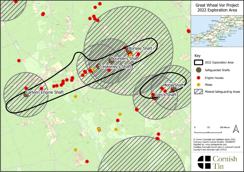
This Phase 1 drilling program consists of 33 exploration boreholes. These will be “diamond drilled”, (ie no pneumatic or percussive drilling, and no blasting). The process essentially uses hollow tubes with a diamond impregnated cutting edge (the bit) to extract cylindrical cores of rock, for research purposes. The diameter of each hole at surface is approx 125 mm (similar to the diameter of a rabbit hole), reducing to approx 96 mm within 10 metres of the surface. Approx 90% of the planned boreholes fall within the minerals safeguarding areas protected under the Cornwall Council Minerals Safeguarding Development Plan Document of December 2018, (copy at Appendix 1).
Question 2
Have you got planning consent?
Yes. Cornwall Council as Mineral Planning Authority granted the necessary General Permitted Development Order (GPDO) in July 2021. This, with a detailed Ecological Impact Assessment and numerous other Reports, can be found on the Cornwall Council planning portal (application number PA21/06669).
Question 3
Where are the boreholes?
The holes are all within the blacklined areas designated as the “2022 Exploration Area” as shown on the Plan in Appendix 1.
Details of the borehole locations have already been provided to the surface landowners on whose properties the drilling is planned.
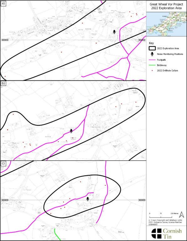
Further details of the approximate borehole locations are in the GPDO (PA21/06669) and are also set out in the Plan: Phase 1 Drilling Exploration Targets, (copy at Appendix 2).
Question 4
What about noise and impact on the amenity of the area?
Noise levels resulting from the operating drill rigs will be very low, and as the rigs are small, and will on each site be screened by straw bales, there will be minimal impact on the amenity of the area. We offered to operate at maximum 55 decibels (as measured at the relevant noise-sensitive receptors) even though the applicable British Standard is 65 decibels, and this is now conditioned in the GPDO. Noise levels will be monitored daily while drilling. There will be no drilling within 50 metres of residential properties. There will be two drill rigs operating seven days a week including public holidays, on 12 hour day shifts, generally from 07.00am to 19.00pm. Only one drill rig will operate on Sundays.
Question 5
Who will be doing the drilling?
Our drilling contractor is Priority Drilling (UK) Limited, a well-established and highly respected drilling provider who for years have been carrying out the drilling for other mineral operators in Cornwall. They will be drilling several other drilling programs in Cornwall this summer as well as ours, all on a similar GPDO basis.
Question 6
When will the drilling start? Where will you drill first?
From now onwards you may see us carrying out surveys and ecological assessments throughout the area, to finalise the drilling schedule. This is flexible depending on ground conditions and ecological factors. We hope to commence drilling before Easter, and the drilling will take approx 6 months.
Question 7
How much public liability insurance do you have?
The requirement in the GPDO is to carry at least £5 million of public liability insurance, and this is sufficient and is in line with industry standards. However, we have listened carefully to the concerns of residents who suggested this should be more. Accordingly, we are pleased to confirm that we have public liability insurance of £10 million, to put any residents’ concerns at ease.
Question 8
Will there be additional phases of drilling after Phase 1?
Any additional phases of drilling will depend on the results of the first phase. As we have explained previously, further Phases may not occur if the results of Phase 1 are not successful enough to warrant further work. The details of any additional phases (including locations) will also not be known until the results of Phase 1 are assessed.
Question 9
Will the drilling cause contamination to the local groundwater supplies?
The drilling will not cause contamination to the local groundwater supplies. The core drilling method is a closed loop system and uses either entirely fresh water or fresh water mixed with specialised drilling fluid to facilitate the cooling of the drill bit and to lift rock cuttings away from the drill bit. The water used will be sourced from drinking water supplies. Due to the use of water, dust is not generated by the drilling. The water used for the drilling will be brought to site by bowser or sourced from local water supplies where possible and stored in a tank. The water, including any drilling fluids used, is recycled using a closed loop system, and returned to surface for re-use. Any waste (including drill cuttings) will be removed from site to licenced disposal sites. Very limited amounts of water (including a very low concentration of any drilling fluids) would likely be lost during the drilling process to the groundwater but these are non toxic
Question 10
How will the boreholes be sealed/decommissioned?
The boreholes will be safely sealed immediately on completion. The wording of the GPDO, which is in line with accepted industry practice, requires a plug to be inserted in the borehole approx 1.6 metres below the surface and the hole capped with at least 1 metre of concrete, with topsoil above. However, some local residents have asked if the concrete infill can be increased, and we have listened carefully to their concerns. Accordingly, we will increase the cement infill above a Van Ruth plug to a minimum of 10 metres, with at least 0.5m of topsoil above the cement, to the surface. Under the applicable Environment Agency Guidance, each borehole should be assessed on a case by case basis however, and the decommissioning of boreholes is subject to any requirements of the Environment Agency. See also Answer to Question 11.
Question 11
Could contaminated water come out of the boreholes at surface?
Given that drinking water will be used in the closed loop drilling process, and the method of capping the boreholes on completion, this will not happen. It is also worth remembering that:
(i) in the 1960s Camborne Tin Limited drilled seven exploration boreholes in the area, under a much less stringent regulatory framework than now applies. None of these boreholes has caused problems with water leaking in or out at surface;
(ii) in the 1960s and 1970s, one of the old mine workings was being used by the Water Board as a reservoir for drinking water for the area; and
(iii) we know that a number of local residents still obtain their drinking water from boreholes on their property, because they have written to let us know this.
The elevation of all planned borehole collars (ie at surface) is significantly higher than the drainage level (adit) of all the mines being targeted within the exploration program. Therefore, in the unlikely event that drilling intersects an old mine void, the hydraulic head of any water within the void would not be great enough for the water to flow from the borehole collar. Our standard procedures for sealing /capping holes are summarised in the Answer to Question 10, and will result in a cap for each hole which is many times thicker than specified within the GPDO. In the highly unlikely event that water of any sort is intersected in a borehole that is under enough pressure to reach the collar of the hole a Van Ruth plug will be inserted as close as practically possible (within a few metres) above the source of the water and the entire hole will be filled with cement from that depth to 0.5m from surface.
Question 12
Are you going to carry out a water sampling program?
Yes. We have started a water sampling program to understand the levels of contaminants within local water courses. Specific areas will be routinely sampled in order to establish the levels of contaminants over time. Further work has also begun to establish the exact levels of water within each of the historic mines. This information will inform future studies into the water and hydrogeological conditions within the mines.
Question 13
Will the drilling cause any issues with subsidence?
Carleen is within an area of historical mining and as result there is already a risk of subsidence caused by the collapse of mine workings. The vast majority of subsidence affecting buildings and infrastructure is from very old and shallow mine workings caused by the migration of made ground or the failure of old caps such as timber or granite lintels. All of our boreholes have been positioned away from such features, as we do not want to intersect mineralised features that have already been mined. The boreholes will be drilled through a mixture of mainly unmineralised slates and granites which are very hard rocks. The possibility of the drilling causing any subsidence in the area is extremely low.
Question 14
What will the mine look like? Request for a picture?
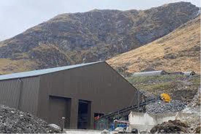
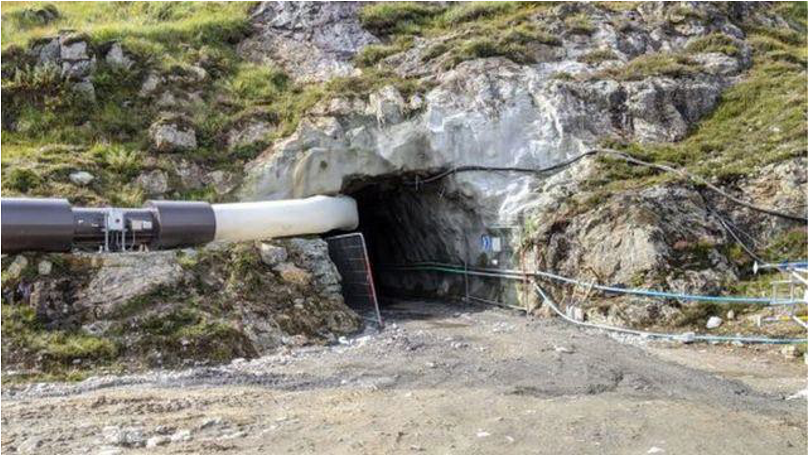
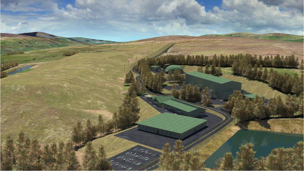
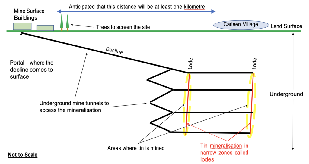
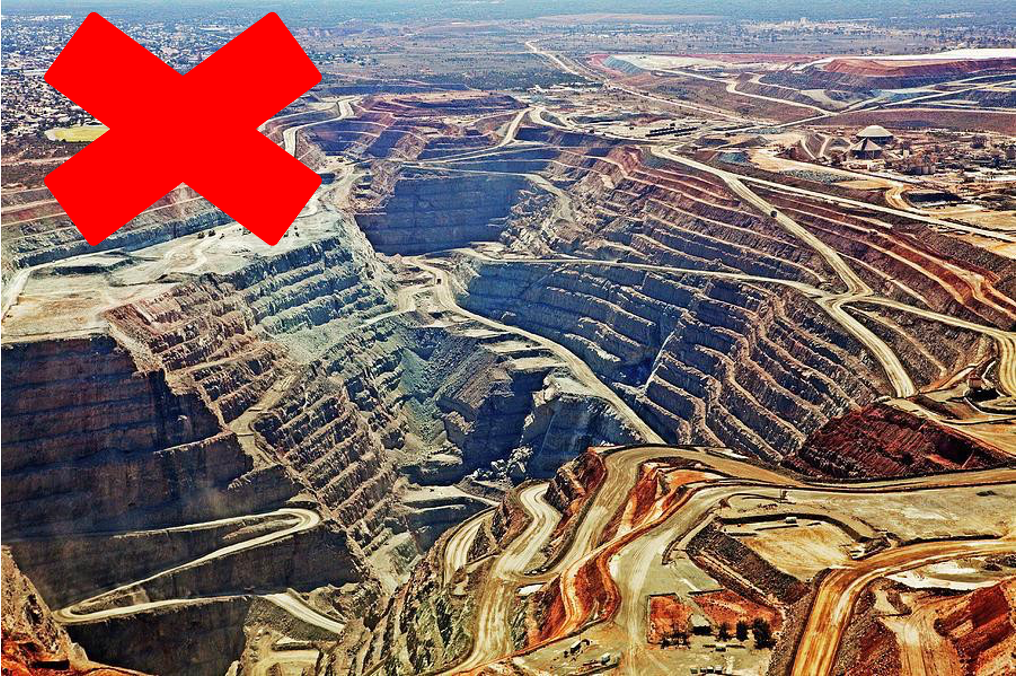
It is important to be clear – we are currently NOT MINING we are EXPLORING. If the exploration phase proves successful, the next stage would be to carry out a very detailed feasibility study which would include design of extraction facilities, environmental studies, planning permits, and many other assessments. Currently, if the area was to be developed into a mine, all operations would be underground, with a small opening known as portal located away from the immediate area, and not close to any residences. There would be a gradual decline (tunnel) from the portal into the underground workings. It is not possible at this stage to know where this portal would be located, but its location, design and surrounding landscaping would be subject to detailed planning permission, as would all other material aspects of the development. However, to give a general idea of what current mining infrastructure can look like, Appendix 3 gives some examples of modern mine design, and includes a schematic (not to scale and for illustrative purposes only) of what an underground mine in the area could be like, if developed in the future.
Question 15
If this is developed into a mine, what happens if Cornish Tin goes bust? How will the environment be protected or remediated as needed?
There will be a remediation bond as required by the Environment Agency, specifically to cover this risk. We will pay for this, which is essentially a form of insurance, and if Cornish Tin becomes insolvent the insured sum is paid to the EA straight away, to enable the EA to carry out its statutory responsibility to protect the environment in relation to the area.
Question 16
If this developed into a mine, (and Cornish Tin has not gone bust), how will you protect the environment?
Some examples of this are:
1)We have a contractual obligation under the standard agreements with Mineral Owners, to build up a Closure Fund over the life of the mine, to remediate and restore the area at the end of the mine’s life.
2) We have pledged to carry out ongoing research with the aim of extraction and processing being as close to a net zero carbon operation as is viable – Green Mining.
3) If this is permitted as a mine, the Environment Agency will impose stringent requirements on the quality of any water flowing out from the mining area.
4) We will seek to use sustainable energy and minimise waste, as far as possible.
5) It has yet to be established whether there is viability for the use of geothermal energy from The Great Wheal Vor area, (for example in a district heating scheme) but we will be researching this as an interesting possibility.
6) It is likely that a high proportion of waste rock will be backfilled into the existing voids underground, thus protecting the amenity of the surface environment.
7) We also intend to set up a Community Fund, our contribution to which would be linked to the net return on the sale of mineral products from the Project Area, for the benefit of the region and with particular focus on the local area. Clearly, the details of this need careful thought and constructive discussion, as we go forward, but in any event it will be several years before a production decision can be taken, so there is plenty of time. We look forward to our future discussions with the community and its elected representatives on this subject.
Cornish Tin Limited
5 April 2022
-
Appendix 1
-
Appendix 2
-
Appendix 3
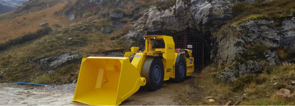
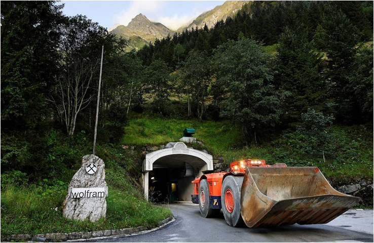
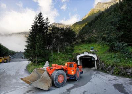
Examples of Modern Mine Designs
UK and Europe
These mines have been designed/built in environmentally sensitive areas
Cononish Mine – Scotgold Resources
Scotland
• Underground gold mine situated within the Loch Lomond and Trossachs National Park
• Mine is currently under construction and nearing production
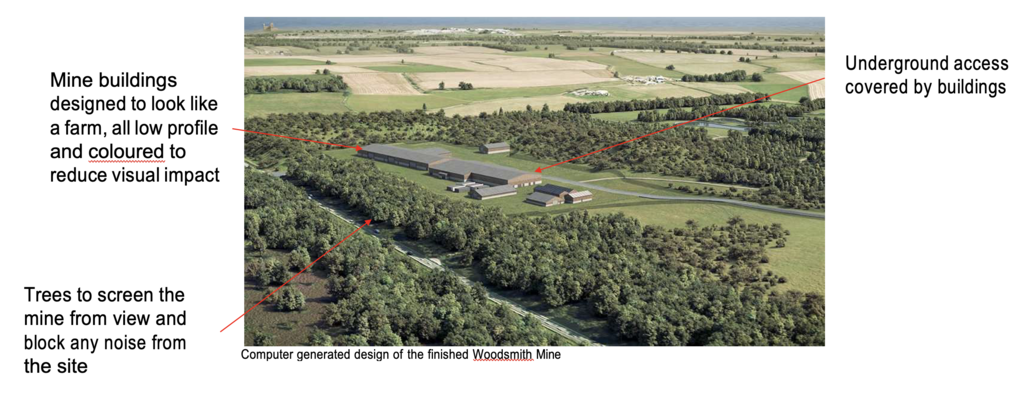
• Underground potash mine situated within the North York Moors
• Mine is under construction
• Access via two shafts with the headframes buried under the surface to limit visual impact
• Processing will be offsite
• This mine’s annual production is going to be many times greater (~50x) than the likely production from any possible future mine at Great Wheal Vor. However, it’s a good example of the mitigation measures new mines within the UK have to take.
Cornish Tin Limited is pleased to provide an update on the progress of its mineral exploration activities in relation to its first flagship project, The Great Wheal Vor, Cornwall, UK.
Read More